

Last updated on June 12th, 2026
From about 1100 to 1250, a community formed in the cliffs high above a creek near Flagstaff, Arizona. Walnut Canyon National Monument gives visitors a close-up look at the remains of this prehistoric community.
With all the things to see in Arizona, Walnut Canyon was one I almost missed. On our way to the Grand Canyon we passed a road sign that said “Walnut Canyon National Monument.” Shortly thereafter I convinced my husband we should turn around and check it out.
I assumed we would discover a scenic spot for hiking. Instead we found a collection of cliff dwellings carved into steep canyon walls by the Sinagua people about 800 years ago. While not as grand as some cliff dwellings in the area, they provide an unusually close-up look into the lives of the ancient community that once lived here.
This story may have affiliate links. I use links to provide additional information, but a few also pay me a small amount if you use them to make a reservation or purchase. You don’t pay extra, but it helps keep this website running without intrusive ads. To learn more, see my policies and disclosures.
About Walnut Canyon
Walnut Canyon holds the ruins of about 80 small Sinagua cliff dwellings constructed between the 12th and 13th century. The canyon itself is also geologically interesting, offering visitors a closer look at some of the same rock formations found just in the Grand Canyon.
As a national monument, the cliff dwellings are protected. But an easy hiking path gives visitors a close look at the remains of 25 different rooms.
Walnut Canyon’s cliff dwellings
Who were the Sinagua?
People have lived in northern Arizona since the days of the wooly mammoth and sabertooth tiger. But the first permanent human inhabitants are believed to be the Sinagua. Arriving around 600 AD, they formed a distinct culture in the Verde Valley (around modern-day Sedona) and around Flagstaff.
Archaeologists call these prehistoric people the Sinagua, which means “without water” in Spanish. It’s taken from the area’s old name, “Sierra de Sin Agua” – mountains without water. However, while this area is dry, isn’t a desert. There are year-round sources of water. And, when the Sinagua lived here, the area was wetter than it is today.
Even so, the Sinagua most certainly settled along and in this canyon because Walnut Creek provided a reliable source of water. In addition, the wide variety of plants and animals living along the creek ensured a plentiful harvest of wild food and game.
👉 Read more about the Singua people
When they first arrived, the Sinagua lived in pit houses and small pueblos and raised crops above the canyon. This is how they lived for most of the time they were here. However, early in the 12th century, they moved into the canyon itself, building homes, community spaces, and storage areas in alcoves and caves sheltered by ledges in the canyon wall.
No one is sure why they moved below the canyon rim, nor why they moved out 150 years later. We do know that they left Walnut Canyon about 1250. And, by the middle of the 15th century, the people identified as Sinagua were gone. However, at least some moved east and then north, where they became part of Hopi and Zuni villages. Today, the Sinagua live on in the historical stories of contemporary pueblo nations.
Cliff dwelling construction, destruction, and stabilization
Large cliff dwellings at several other Sinagua sites have multiple levels and housed several families.
That wasn’t an option at Walnut Creek, where the natural alcoves and overhanging ledges aren’t very large. (Or, at least, the ones I saw weren’t.) Most seem to have been single-story structures with 2-4 rooms separated and enclosed by stone walls. However, there were larger structures too, including at least one thought to have 16 rooms.
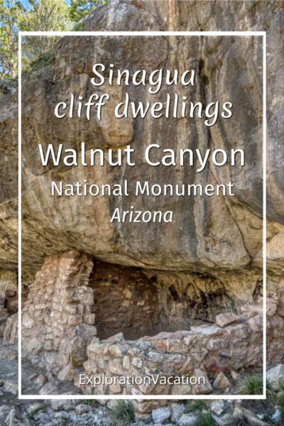
Walls were built from rock using a mud mortar. They were covered with plaster and had small vents at the top and bottom to help with air flow. Unlike many cliff dwellings, which are entered through the roof, these dwellings were entered through doorways with wood lintels.
Although interior spaces were small, they offered a sheltered space for cooking, sleeping, and storing supplies and household goods. Rooms stayed dry throughout the year, and most were situated to stay cool even in the scorching heat of summer. Likewise, a fire could keep them warm through northern Arizona’s cold and snowy winters.
After the Sinagua
Protected as they are from rain and sun, the walls of cliff dwellings in the American southwest can stand for a very, very long time. But they are no match for human destruction.
About 600 hundred years after the Sinagua abandoned them, Walnut Canyon’s cliff dwellings were discovered by hordes of 19th century tourists and pot hunters seeking archaeological objects to collect and sell. They not only ransacked dwellings in their search for ancient items, but dug up floors to uncover buried items. Some even used dynamite to make the search easier.
This sort of destruction occurred across the southwest. At Walnut Canyon it reached a point where local residents sought federal help to stop it. In 1904 the Forest Service stationed a ranger at the site to assist visitors and monitor activities. Further protection came in 1915, when President Woodrow Wilson made Walnut Canyon a national monument. The protected area was enlarged by Franklin D. Roosevelt in 1938.
During the 1930s the Civilian Conservation Corps (CCC) stabilized the walls of cliff dwellings, constructed buildings for workers and visitors, and built or improved much of trail used today. Sites have also been stabilized during archaeological excavations over the decades.
Walnut Canyon was listed on the National Register of Historic Places in 1966. The cliff dwellings are just part of the listing, which includes 230 prehistoric sites within the national monument’s boundaries. Most, but not all of those sites were used by the Sinagua between 500-1250 AD.
👉 Read less
Geology
Carved by Walnut Creek over 60 million years, Walnut Canyon is a twenty-mile-long and 400-foot-deep cut into the plateau near Flagstaff, Arizona. Of this, only six miles of the canyon are included in the national monument.
The canyon walls are made up of three layers: Kaibab limestone, the Toroweap formation, and Coconino sandstone.
These are the same layers visible in the Grand Canyon just to the north. (The Grand Canyon is deeper, so additional layers are exposed there.)
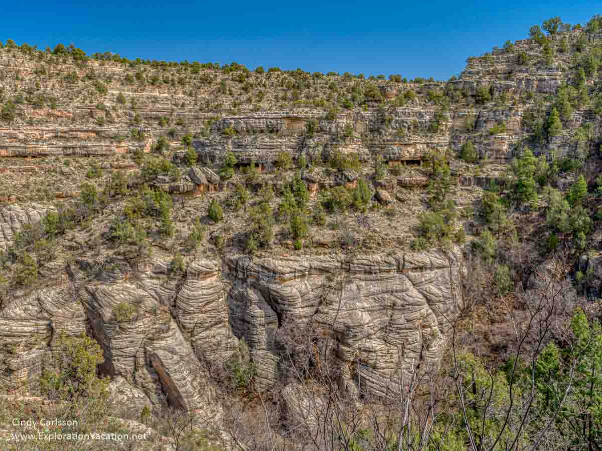
The top layer, the Kaibab limestone, is itself a series of layers. Originally a seabed, each layer contains a mix of rock and varies considerably in hardness. Because of these variations, it erodes irregularly, creating layers of alcoves, caves, and ledges where the Sinagua built their dwellings.

Below, the darker Toroweap formation includes a mix of limestone, sandstone, gypsum, and shale. It erodes more easily than the canyon’s other stone. This layer supports many of the trees and brush that grow along the canyon walls.
At the lowest level of the canyon, the harder Coconino sandstone twists and turns above Walnut Creek like the windblown sand dunes it once was.

On the Island Trail
From the top of the rim behind the visitor center, a trail dips partway into the canyon and then wraps around a mountain of rock partially severed from the rest of the canyon wall by the meandering creek below. It’s not really an island, but it feels like one.

Although this land bridge drops almost 200 feet, there is still a lot of canyon below.
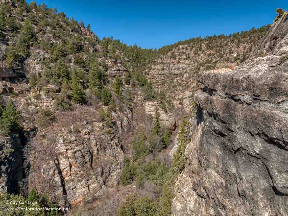
But there’s still a lot of canyon above too.
Rock walls tower above the creek on all sides, their faces marked by bands of color. It looks like a rugged, inaccessible wilderness.
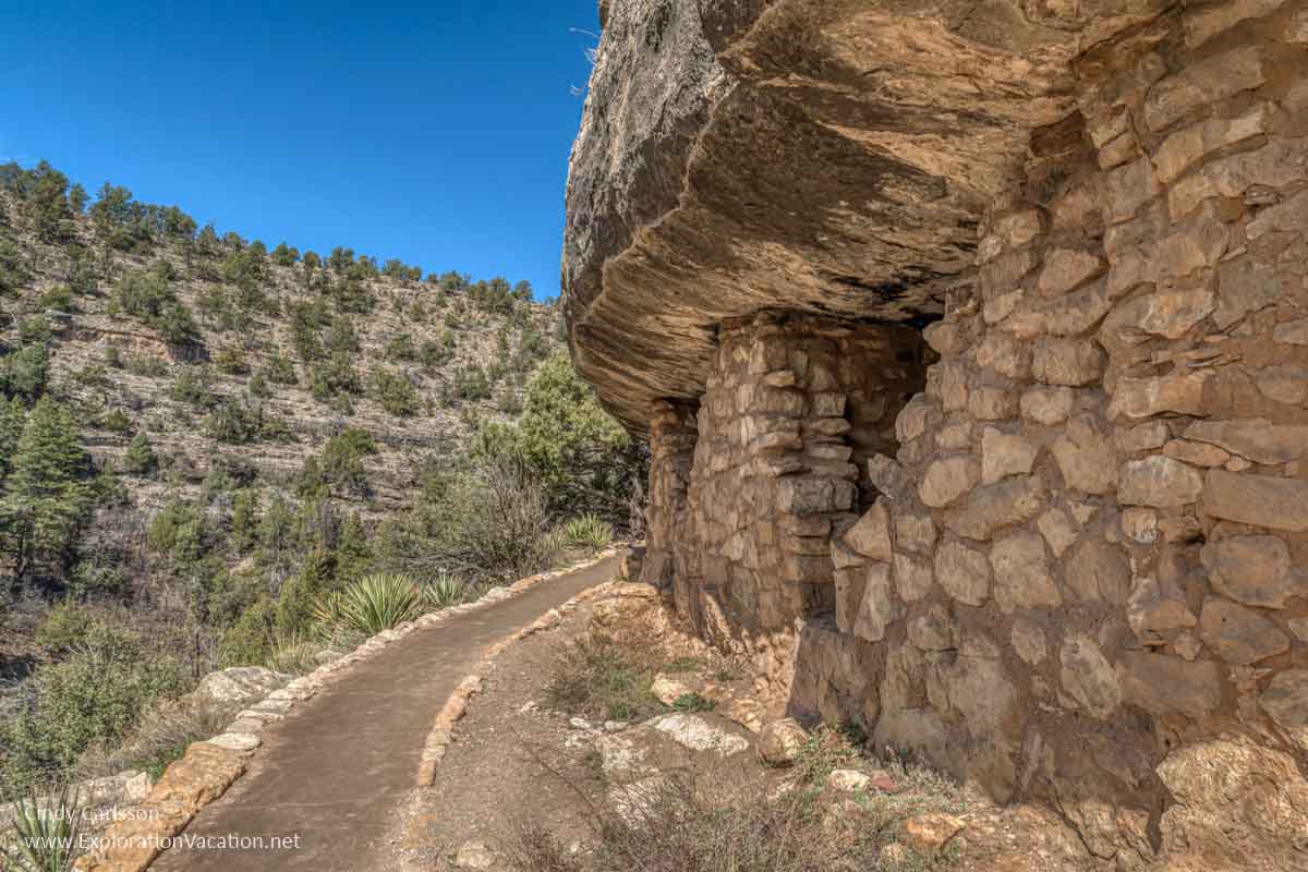
But look closer. See those overhangs and caves in the cliff face? Look even more closely and you’ll see many are filled with what looks like brick walls.

The more you look, the more you see.
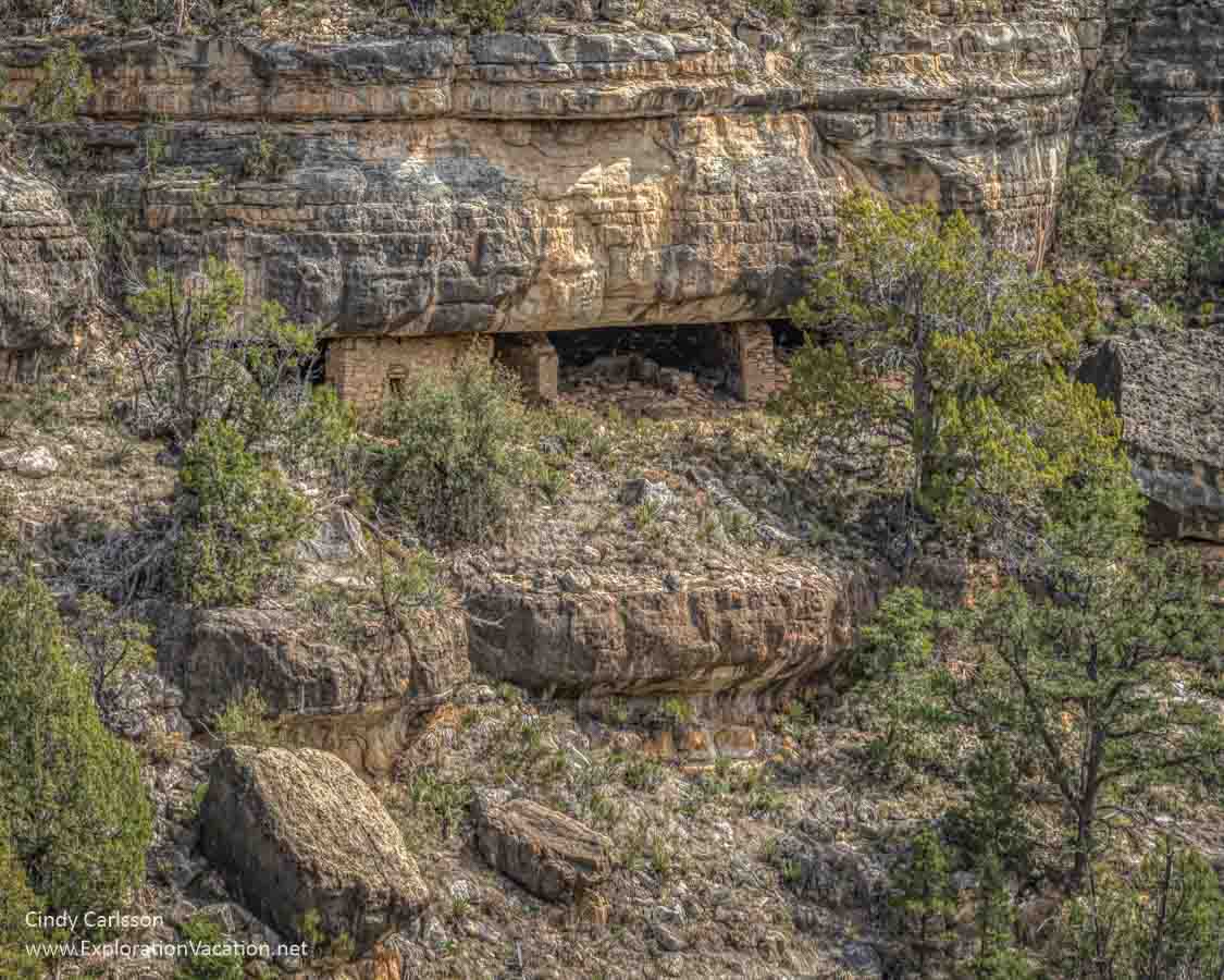
You are surrounded by cliff dwellings, storage areas, and other structures built by the Sinagua about 800 years ago. It’s all part of a village that once housed 100 or more people.
But you don’t have to look at them from a distance. As the Island Trail winds around this particular bit of rock, it takes visitors right past the remains of 25 rooms once used by this ancient community.
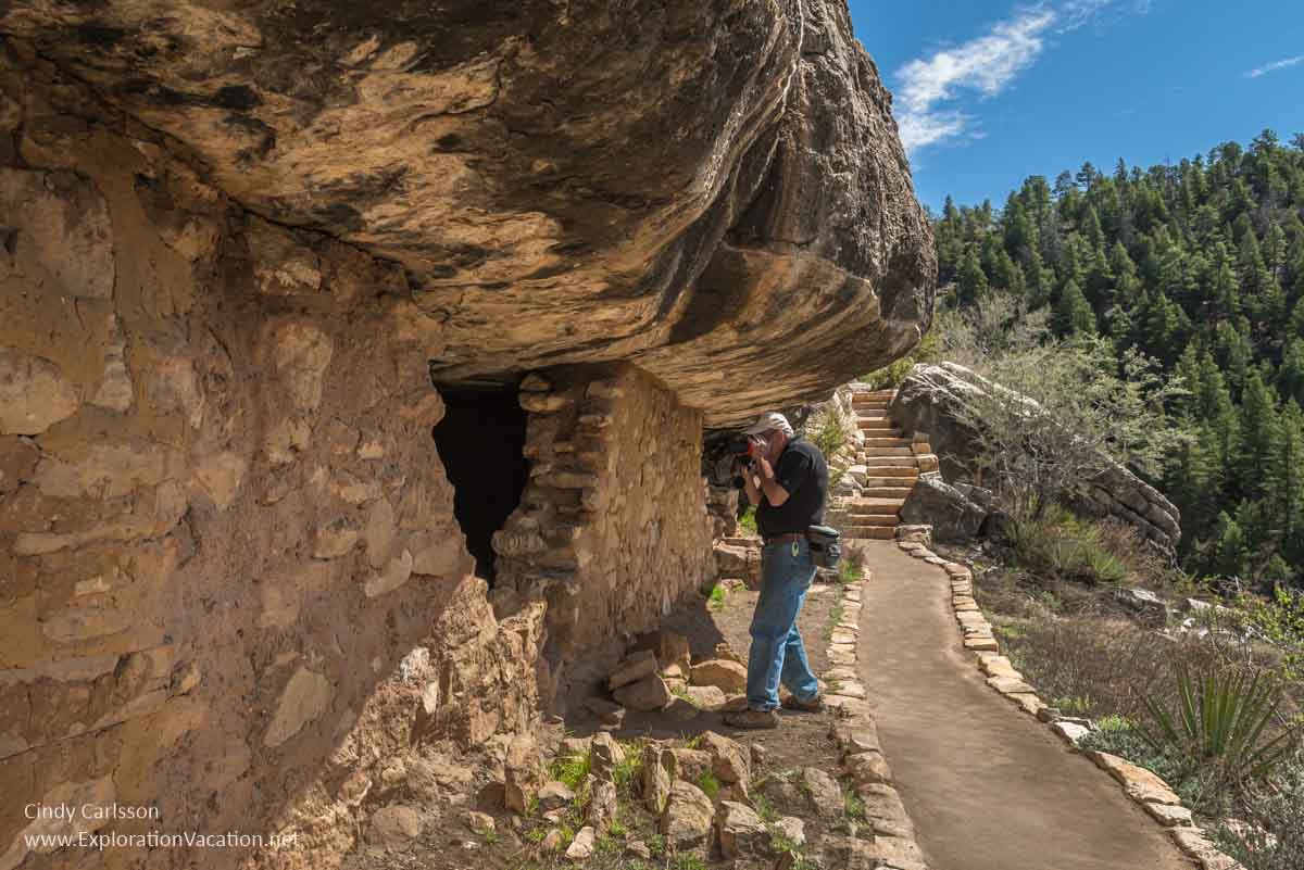
It’s often unclear now exactly how any given room was used by its long-ago residents. But, if you stop and let your mind drift, it’s not hard to imagine this canyon filled with the sounds of life in a small village.


The trail wraps all the way around the island, although most of the building sites are on one side.
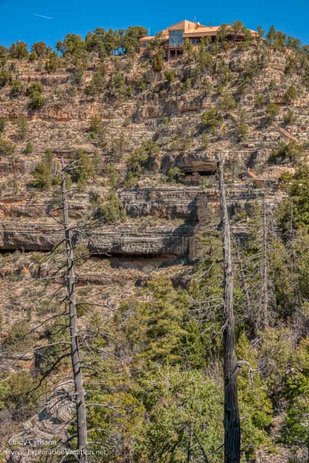
As you get closer to where the trail connects to go back up, you’ll have great views of the visitor center. (And a reminder that it’s a bit of a hike to get back out of the canyon!)
Plan your trip to Walnut Canyon
Walnut Canyon National Monument is an easy stop if you are visiting Flagstaff or headed to the Grand Canyon from the south or east.
Where is Walnut Canyon
The Walnut Canyon visitor center is about 10 miles southeast of Flagstaff, Arizona. For Route 66 fans, it’s just south of the historic Mother Road between the cities of Winona and Flagstaff.
Driving
Walnut Canyon is about a 10-minute drive from Flagstaff.
👉 Read more about planning a trip to Walnut Canyon
The best access is east of Flagstaff via exit 204 (Canyon Road) from I-40. Once leaving the highway, the park is just three miles down the road. Other roads leading to the park entrance are narrow and twisting. At least one is not maintained and requires a high-clearance vehicle.
The road into the park is paved. However, there is little space for larger vehicles to turn around once they start down the road to the park. (Vehicles over 40 feet may find it impossible to turn around.) Nor is there any turn-around space for oversized vehicles when the park is closed. Don’t take an oversized vehicle down to the national monument area unless you know it is open!
Biking
It’s possible to bike to the national monument, although it sounds a little tricky. Mountain bikers will find a variety of trails that lead into the area around the national monument from Flagstaff. Some of these go along a portion of Walnut Canyon, but (apparently) none go into the national monument itself. (The national monument only protects the portion of the canyon where most of the cliff dwellings are located. There’s lots more canyon to explore beyond it.)
Bus
There’s no public transportation to Walnut Canyon. Tours are usually available.
When should I visit?
Walnut Canyon National Monument is open year-round, closing only for Christmas and New Year’s Day. However, hours may be reduced on other holidays. Check the park website for current hours before you go.
Weather
Arizona weather varies dramatically throughout the year, and sometimes throughout the day. At over 6,000 feet above sea level, Walnut Canyon can be cold, snowy, and icy in winter. Summer brings hot sunshine and afternoon thunderstorms. Strong winds are possible at any time, but most common in spring.
No matter what the weather is like when you arrive, realize that it can change quickly. Dress in layers and always bring water.
Hours
The park is open daily from 9 am to 4:30 pm, although the visitor center seems to close over the lunch hour. If a ranger talk is scheduled (they are held when staff is available), it will be at 10 a.m. and/or 2 p.m.
Because visitors must be out of the park by 4:30 (rangers do a sweep before locking up for the night), access to the Island Trail closes at 3:30.
There is no access to any part of the national monument area, including trails and parking areas, when the park is closed. Nor is there a place for large vehicles to turn around once the park closes for the day.
Seasonal events and activities
Ranger-led discovery hikes are offered between July and Labor Day. There are two of these, an easy Range Cabin walk and a strenuous Canyon Ledge hike. Reservations are required.
Once you arrive
The road ends at the visitor center, with parking along a loop. If you already have the appropriate park pass, be sure to hang it in your window before leaving your car. Otherwise, head to the visitor center to purchase one.
Fees
The current feel schedule is a little confusing. You can enter for free with a regular park pass. Otherwise it appears to be $25 per vehicle or $15 per person (if you bike or hike into the park).
Walnut Canyon National Monument accepts both the Flagstaff Area National Monuments Pass and all permutations of the America the Beautiful Pass. All of these passes allow entry by the pass holder and up to three other adults.
All passes can be purchased online or at the park, but you must use a credit card.
Visitor Center
Perched high above the canyon, the large windows in the visitor center offer great views of the canyon. This is also the place to get information on the site, visit the gift shop, and use the toilet. (There are no toilets along the trails.)
Trails
Walnut Canyon has two trails with views of the cliff dwellings – the Island Trail and the Rim Trail.
Although it is a bit of a climb back out, the Island Trail is the way to go if you can do it. Aside from the climb back out of the canyon (there are a LOT of steps), it’s an easy walk that offers close-up views of the cliff dwellings.
These are the only trails in the park. There are no bike trails. Nor is there access to other cliff dwellings or the creek.
All visitors must be off the trails before the park closes.
Rim Trail
The Rim Trail is an easy trail with two scenic overlooks along the top of the canyon. The first section is paved and fully accessible. The entire trail is less than a mile long.
Island Trail
The Island Trail, featured above, is the trail to walk if you are at all capable of doing it. The one-mile paved loop trail gives visitors a close-up view of more than 20 cliff dwelling spaces and great views across the canyon to other cliff dwellings. However, the trail drops 185 vertical feet into the canyon via a series of stairs and ramps and visitors must climb back out again. That might not sound difficult, but keep in mind that the elevation here is about 7,000 feet.
Aside from the climb out of the canyon, the short trail (less than a mile) is paved and mostly flat.

Visitors must stay on the trail. Do not climb or lean on dwelling walls or disturb any part of the site.
Pets are not allowed on the Island Trail.
Services
The store in the visitor center sells a variety of souvenirs, books, maps, candy, and a few snack foods.
The visitor center has a station for filling water bottles, but bottled water is not available in the park. Bring a water bottle or buy one in the park store.
Other than the granola bars, cookies, and other packaged snacks available in the park store, there is no food available. Instead, bring your own lunch and enjoy a picnic at one of the tables along the rim near the visitor center.
👉 Read less
Lodging
Camping is not allowed within the national monument. However, camping is available at a number of nearby national forest campgrounds. And, of course, there are plenty of lodging options in Flagstaff. Check your options on Booking.com or Expedia.
Guidelines for visiting archaeological sites
While visitors should treat every place they visit with the utmost care and respect, that is particularly true of southwestern archaeological sites like Walnut Canyon. Not only are these sites extremely fragile, but they are still connected to contemporary Native American communities. Sites like Walnut Canyon are the homes and burial places of their ancestors. These are precious, often sacred, places and you are a guest.
In addition, moving or removing objects and defacing or otherwise damaging a historic site on public land is a crime!
-
- Don’t pick up or touch any object at the site. Removing or even just disturbing items at historic sites on public land, including historic trash, is a federal crime.
- Don’t touch rock art. Simply touching it with your fingers leaves oils that cause damage. And never try to make rock art easier to see by tracing over or rubbing it with your finger, a stick, or other object.
- Do not leave graffiti or your own “artwork” on any surface.
- Don’t touch, sit, lean, or walk on walls or roofs.
- Stay on established trails. This is important within an archaeological site, but also in natural areas around it, as the top layer of desert soil is a thin, living crust. Once damaged, it takes years to regrow.
- If using hiking poles, make sure they have rubber-tips to avoid scratching floors.
- Do not litter. This includes organic material like orange peels, which attracts wildlife that can damage the site or harm other visitors.
- If pets are allowed, keep them leashed and far from archaeological sites.
- Report vandalism.
See more at best practices for archaeological tourism (PDF).
Visit other Sinagua sites
Although they lived in northern Arizona as early as the 6th century, the Sinagua flourished in the Verde Valley area around Sedona and north to Flagstaff from about 1100 to 1400.
Throughout their time here, the Sinagua built villages (usually called pueblos) both on the land where they farmed and in nearby cliffs. It’s easy to visit a number of these sites while in the area.
Tuzigoot National Monument
West of Sedona, just outside the small town of Clarkdale, Tuzigoot National Monument preserves a hilltop pueblo built by the Sinagua. The pueblo is three-stories high and has more than 100 rooms. The Sinagua abandoned it after 1400, making it among the last inhabited sites.
Visitors can walk through the pueblo itself. There is also a museum and a nature trail through a marsh.
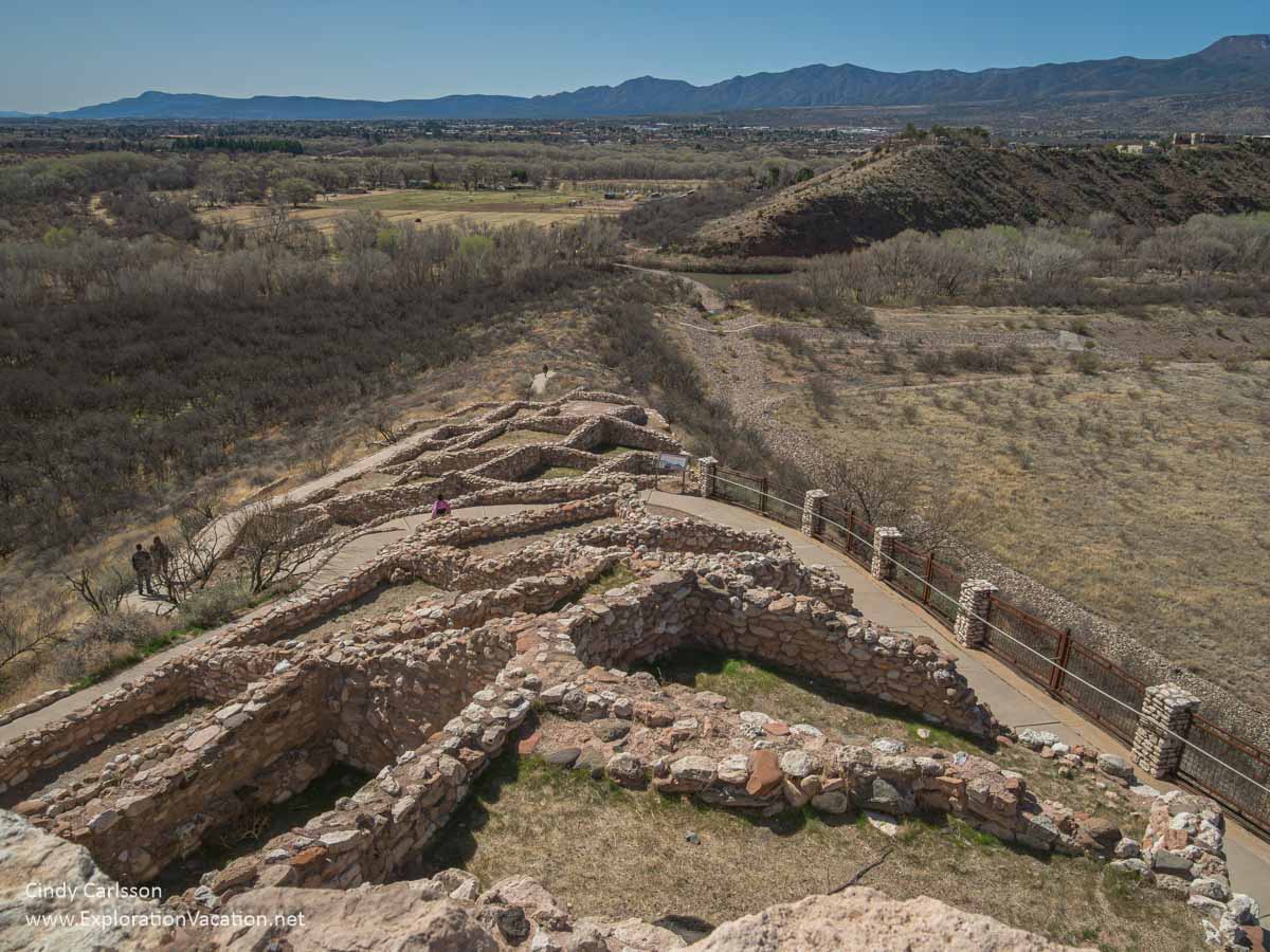
View from the an upper level of the Tuzigoot ruins.
The National Park Service currently has good historical information their Tuzigoot webpage — this is a change from a few years ago. For even more on the history of this site and what you will see there, check the American Southwest page.
👉 Read more about other Sinagua sites you can visit
Wupatki National Monument
Just north of Walnut Canyon, Wupatki National Monument preserves hundreds of ancient Anasazi and Sinagua pueblos scattered over a vast area. However, only the largest is open to the general public.
These sites were abandoned about the same time as Walnut Canyon.
Unless I’m missing something, there is virtually no information on this site (aside from basic operations info) on the National Park Service website. Instead, check the American Southwest website to learn what you will see at Wupatki and get a bit of history.
Montezuma Castle National Monument
South of Sedona, Montezuma Castle National Monument preserves a five-story Sinagua structure located in a cliff face high overhead. It dates to about the same time period as the dwellings at Walnut Canyon, but seems to have been abandoned about a century later.

The ruins are visible from a short trail below the cliff. Visitors cannot climb up to the ruins. However, the trail runs along a creek, making it a pleasant, shady spot throughout the year.
The national monument also includes nearby Montezuma Well. This is a natural water-filled sinkhole with a few cliff dwellings.
Palatki Red Cliffs Heritage Site
The Palatki Red Cliffs Heritage Site protects two large Sinagua cliff dwellings and a rock art (mostly painted pictographs) site used from the time humans first arrived in the area (as much as 12,000 years ago) through the modern historic era. The cliff dwellings here and at neighboring Honanki were the largest in the Red Rock area from 1150-1350.

Palatki is located just west of Sedona. The site is managed by the Coconino National Forest. Tours are usually available daily, but limited to 10 people. Advance reservations are required.
Honanki Heritage Site
The Honanki Heritage Site preserves the other of the largest Sinagua cliff dwellings in the Verde Valley, along with more than 2,000 pictographs painted on the site’s rock walls. Like those at nearby Palatki, the pictographs here were created over thousands of years by many different groups of people.
The site is located just west of Sedona and managed by the Coconino National Forest. It’s usually open daily, however, the drive into the site is on an unmaintained dirt and rock road that isn’t suitable for all vehicles. But, for those who don’t want to drive there, Pink Jeep offers a tour.
V Bar V Heritage Site
The V Bar V Heritage Site features rock walls covered with petroglyphs. Most were created by the Sinagua, but there are also markings from others who came both before and after.
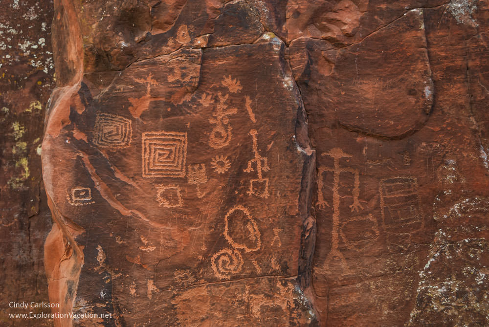
There are over 1,000 petroglyphs visible here, including what may be a Sinagua solar calendar.
Bar V Bar is managed as part of Coconino National Forest. It’s located just off I-17 south of Sedona. The site is only open to the public weekends, from Friday – Monday.
👉 Read less
Resources and further reading
Although the entire national monument was added to the National Register of Historic Places in the 1960s, a complete review of the site was completed in 1987. It provides an in-depth overview of the site and what was known about it at that time, although the illustrations are all but impossible to see.
At some point during my travels around Sedona, I picked up the Guide to the Heritage Sites: Coconino National Forest Red Rock District published by the US Forest Service and Friends of the Forest. While focused on the Palatki, Honanki, and V Bar V sites near Sedona, it also provides more general information on cliff dwellings and the Sinagua people. Unfortunately, this booklet doesn’t appear to be available online anywhere. Look for it if you visit any of the Red Rock sites or Coconino visitor centers.
For links to a whole variety of historical documents related to USA national parks and monuments, take a look at the National Park Service Electronic Library. While the material available varies greatly by park, but it includes everything from tourist brochures to management plans and environmental assessment documentation. It even includes a few videos. There is a lot of material on Walnut Canyon.
Check my travel photography website for more photos from Walnut Canyon and throughout Arizona.
Click on the photo links below to visit more Sinagua sites or discover what else Arizona has to offer.


Really enjoyed your photographs. We were there several weeks ago. Clicked off more than a few. Loved the walk — although the trek back up is tough on the old knees. Being able to step right into this ancient world was a totally captivating experience . . .
And I’m always surprised by how few people seem aware of it.
We were there a week ago. Loved the walk — although the trek back up is tough on the old knees. Being able to step right into this ancient world was a captivating experience . . .
Bob, I’m with you on both: tough on the knees but a captivating experience. Well said!
The Walnut Canyon’s cliff dwellings are my favorite Indian ruins in Arizona. We visited this place three times so far, at different times of year. The dwellings look particularly beautiful in winter, when there is snow around. You’ve got some beautiful up-close pics of the dwellings across from the Visitor Center. Wow, I wish we could reach those cliffs also.
I never thought about visiting when there is snow, but I can see that it would be really beautiful. I know what you mean about the dwellings located elsewhere in the canyon – I want to take a look at those too! Have you been to Hovenweep up in Colorado? It’s probably not the same as when we stumbled across it more than a decade ago, but when we visited you had the feeling there that you were actually discovering the ruins.