Last updated on March 25th, 2026
In 2005 I visited California to attend a friend’s wedding and took a bit of time to explore a bit.
I use links to improve your experience using this website. Some may be affiliate links that pay me a small commission if you use them to book a room, rent a car, or purchase goods or services. You don’t pay extra, but it helps keep this website running. To learn more, see my policies and disclosures.
The San Francisco Flower Market
A sunny Saturday begins with a trip to the wholesale flower market in San Francisco. The last time I was here, early-rising members of the public could mingle with floral professionals and buy big bundles of cut flowers at wholesale prices. The warehouses were generally a little dirty and industrial, fitting for a place dealing in an agricultural commodity.
The flower market has since been discovered by the larger world. Apparently this discovery led many of the businesses to dress-up their entrances, in some cases even creating retail spaces with the look and feel – and prices – of a traditional florist. Behind these spaces, the warehouses where customers negotiate piles of cardboard, forklifts, hoses, and puddles are still the same. However, along with the dressed up retail spaces and the lovely coffee shop featuring a couple dozen types of pastries came the end of wholesale prices to the public. Nor can you still wander in at 5:30 a.m. to buy your flowers alongside “the trade.” Now we must wait until the market opens to the public at 10 and ends – apparently – at the whim of each vendor. Some actually close at 10, thus eliminating a number of otherwise promising options.
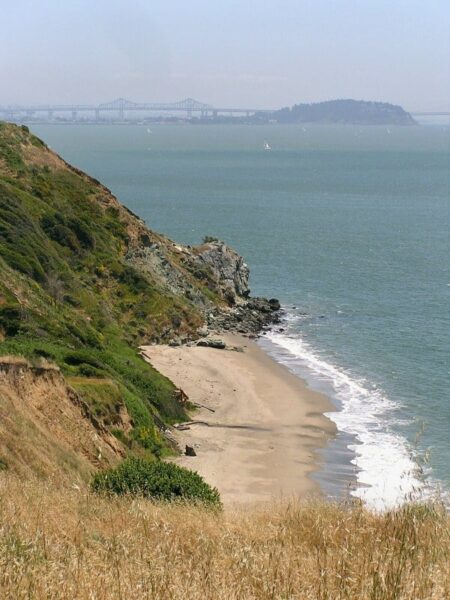
Angel Island
Friends have arranged to join us on an outing to Angel Island.
If you stand at the ferry terminal in San Francisco looking out into the bay, Angel Island is the large island behind Alcatraz. During the few thousand years this island has been inhabited by Miwok Indians, Spanish explorers, cattle rancher, U.S. military personal, Chinese immigrants, and Japanese, German, and Italian prisoners of war.
The military used the island for nearly 100 years, beginning at the time of the Civil War. Almost 30 after that first military garrison had arrived, a quarantine station opened on the island, providing a facility where ships from foreign ports could be fumigated and immigrants suspected of carrying disease isolated. In 1910 complete immigration facilities were established on the island and it became the Ellis Island of the West, where immigrants from all countries were processed and many Chinese immigrants detained for extended periods. Today the island is a state park where the leavings of history intermingle weirdly with natural areas and stunning views of the surrounding cities in all directions across the bay.

 The island itself is a mix of open hillsides, shady woods, and incongruous structures: A farmstead, rows of Victorian frame houses – now vacant, but perfectly preserved and neatly aligned along the seaside muster grounds of Camp Reynolds, large institutional structures set on neat lawns cut out of the wooded hillside, hulking abandoned administrative buildings open to the elements and to visitors, the huge waterside hospital, small wooden shacks hidden in the trees. All but the few structures preserved as museums stand empty in varying stages of upkeep or decay.
The sun is shining and the views across the water are amazing, so we skip the museums and enjoy the odd juxtapositions of this place that is part wilderness part decaying Victorian majesty.

Into the Central Valley
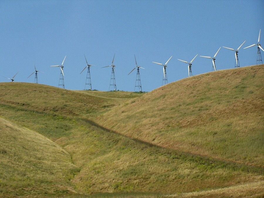
We leave the Bay Area early to make the long drive to Los Angeles. Once we are beyond the ever-expanding Bay Area, the golden hills along I-580 become dry and desolate. Then, abruptly, we are surrounded by wind turbines. Rows of white towers with arms twisting lazily, march over the top of every hill. Another row marks the top of the next hill, and the next, and the next. Looking back, the hills are spiky waves of white towers. Cows graze, seemingly unperturbed, around and beneath them as if there were nothing extraordinary about the scene. Yet it seems slightly surreal, like something out of a movie about life on earth once the outer space aliens have taken over. Then, as unexpectedly as they appeared, there are no more.
The rest of the drive is uneventful. The west side of the highway is desolate with a few scattered cows and the occasional abandoned farmstead. The east side of the highway is steady streak of orchard and grove. Signs on fence posts boldly announce “almonds” and “pistachios,” while others proclaim the bounty of this land on signs too small to read at freeway speeds. It is the California Aquifer that makes this possible. The aquifer is our companion as we drive, wandering along side us as it carries water that originated in the Cascades south through the Central Valley.
We stop at a rest area where we are greeted by a handwritten sign on the restroom door: “Rattlesnakes are now out so watch out for them.”
Santa Barbara
We have only a couple of days to head up the coast and I have requested a stop in Santa Barbara. My husband is hesitant – isn’t this just an expensive tourist stop, shouldn’t we get farther up the coast before we stop? I plead my case: The guidebook says “Santa Barbara is an example of how tight zoning can lead to a city where it is a pleasure to live.” We are going here.
The minute we leave the highway I know I will like it here. The gateway to the waterfront park – and the tourist information center – runs through a shabby light industrial area. Here the street’s center median has been carefully planted to produce a riot of color beneath swaying palms. I doubt most visitors realize they are passing corrugated steel sheds grounds littered with old equipment and supplies. Instead, the median directs your sight to the vista at the street’s end, where the ocean awaits.

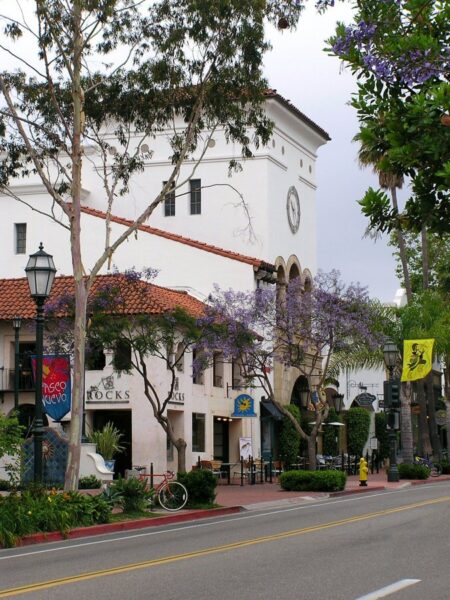
Downtown Santa Barbara is beautiful.
It is filled with both historic and tastefully historic-looking buildings, but without feeling fake. New buildings – even shopping malls – blend into the scene, but without looking as if they are trying to fool anyone. The style creates a bright, cheerful sense of harmony, with white stucco with red tile roofing set off by decorative tile and plaster details. Signage is bright, creative, and cheery. There are trees and flowers everywhere. The sidewalks are wide and inviting with planters and benches and open courtyards perfect for lounging.
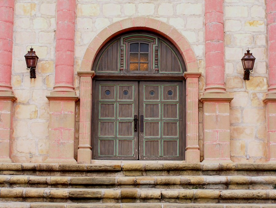
As we stroll down the main thoroughfare I wish I had time to wander every street, alley, and courtyard; but we agree to limit our exploring to a walk through the core of the historic district, with a quick stop inside the 1929 courthouse with its dazzling faux Moorish tiles and painted ceilings followed by a trip through the lovingly restored pink and white confection that is Mission Santa Barbara.
Solvang
We have our one negative encounter of the trip in a place I had vowed to avoid.
Solvang was founded in 1911 by a group of Danish settlers. It is an old historic town turned tourist-trap, first as a Danish fantasy-land for those wishing to connect with their heritage and now as a kitschy base for touring and tasting the wines of the Santa Ynez Valley – as exemplified in the movie “Sideways.” I know enough to have decided I would not like it. However, I discover there are a limited number of places to stop for lunch along this section of the coast, so by 1:30 my snobbery is dissipating in light of images of open-faced sandwiches and Danish pastries. At the turnoff we leave behind both the coast and the low-hanging clouds and head over the hills to Solvang.
In downtown Solvang we step out of the car into a hot, sunny day. Ahhh. Everything IS too cute, but it is also cheery in the sunshine. The sidewalks are shaded, and flowers bloom alongside the brightly painted hotels and shops. This isn’t so bad. It is a beautiful day, we can run into the Tourist Information office, get a map, wander around, and then find a good restaurant and maybe even do a little shopping.
In the tourist information office, we are ignored for some time by a 40-ish woman dressed in an exaggerated version of a traditional Danish costume. When she finally turns her attention to us, it is to explain that California needs to “send back” recent immigrants. My reaction is shock: A woman dressed in a fake ethnic costume and working as an ambassador for a city that has completely cashed in on its ethnic heritage, doesn’t believe today’s immigrants should be allowed to stay in this country? The same country that allowed her immigrant ancestors to prosper? My second reaction is to leave town immediately.
Back on the sidewalk, the perky, ethnified buildings no longer seem cute or silly, but slightly sinister – a mask covering a more complicated and less attractive reality.
Big Sur
The serpentine path that is Highway 1 winds through the coast’s namesake settlement, Big Sur. I expect there to be a town. Perhaps there is one somewhere off the road, but from the highway the surrounding area appears undiscovered, with rugged coastline far below and only an occasional home or ranch or resort showing itself.
We never find anything a Midwesterner would recognize as a town, but we do find the Big Sur Bakery, a very chic hippy coffee shop. The line at the counter moves slowly, but that gives us time to watch in awe as simple beverages become works of art with marbled whip cream tops and strategically placed streaks inside the tall clear glasses. Hot chocolate and chai will never be the same now that I know what they can become in the hands of an artist!

Next time we will stop for a meal and see what sort of artwork we are served.
The Monterey Peninsula
A tip on the Lonely Planet website brings us to Asilomar Conference Grounds for the evening. Asilomar (a made-up word derived from Spanish to mean “refuge by the sea”) is adjacent to the Monterey Bay Marine Sanctuary in the town of Pacific Grove. Despite its pretentiousness, this form YWCA conference center is a picture perfect display of a coastal California woodsiness.
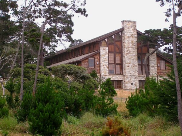 Built under Julia Morgan in 1912, the conference center (now a private concession within the California State Park system) boasts an auditorium, dining hall, meeting rooms, and a variety of lodging all built in the arts and crafts style that was so popular at the time.
Our room is not particularly small; although the bathroom is the most miniscule I have come across thus far. There is a fireplace, well-stocked with wood; built-in cabinets for storage; a large casement window with no screens to obstruct our view of the grounds and the ocean beyond; a tiny, ocean-view deck; and two twin beds. While it isn’t the ideal room for a romantic get-away, it comes close.
The Marine Sanctuary features dunes, deer, beaches, and lovely waves that come crashing noisily ashore as the tide moves in. From our window we can see the ocean and, despite the coolness of the night, we leave the window open so we can hear the waves.
The Golden Gate
Back through San Francisco and finally – for the first time this trip – across the Golden Gate. Since we are leaving the city, there is no toll. On the Marin County side we stop and I gawk with the other tourists. It is amazing what a clean design and some orange paint can do.

Sonoma County
I was here a few months earlier, when these golden hills were a brilliant emerald green and before the grapes had leafed out. Somehow it seems a different, more agricultural place now on the cusp of summer.
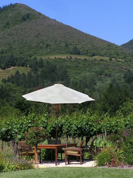
Sonoma County was an agricultural area long before it became wine country. The vineyards now replace the apple orchards that had been a vital source of income for previous generations; although the orchards themselves were planted in the fields that previously grew hops. I wonder when the vineyards will be replaced and what will replace them. But right now, there are vineyards everywhere. They cover the small valleys between the hills and march up into the remaining woods that protect the steepest slopes. Grape mania has struck this area and everyone seems to have a few vines. Up-scale housing developments feature front yard landscaping consisting of well-tended vines.
A version of this article was previously published in the newsletter of the Minnesota Chapter of the American Planning Association.